EVERYTHING YOU NEED TO KNOW ABOUT HIKING IN EL COCUY
Thinking about attempting one of Colombia’s secret hiking gems? we’ve collated everything you need to know
How to plan your trip, why to go, how to get there, where to stay, what hikes you can do, guide information, fitness requirements, what to pack, how much it all costs and everything else you need to know
** Update:2023 ** Readers of this post have reported back that the guide we recommend below is no longer working in the area. Instead, look up Martha at hostel El Caminante
In art there is a term known as ‘aerial perspective’; the technique of creating depth in landscapes through using paler shades as the view recedes. A way to capture atmospheric haze, built up from countless miles of heavy air. As we wove our way along the sinuous roads into the Sierra Nevada del Cocuy, that gradient of colour was endless in the afternoon light. A land of wide & deep horizons.
Colombia is a country of national parks; from the ancient sea-bed desert of the far north, to the endless depths of the Amazon in the south, the diversity of natural wonders is staggering. But there is one, deep in the heart of the Andes, that seems to slip under the radar; Parque Nacional Natural El Cocuy.
We’d caught a bus early one morning from Bogota, seeking its soaring snow-capped peaks, sharp-cold mountain lakes, and some of the best high-altitude hiking in Colombia.
Why is Sierra Nevada del Cocuy so special?
Located almost 400km from Bogata to the North East, Sierra Nevada del Cocuy is a landscape carved and defined by its glaciers. Two parallel mountain ranges boast 25 snow-capped peaks over 19 miles. Acres of untamed páramo & valleys of alien-like fraillejones dominate the lower altitudes, the jewels in the crown of an impressive eco-region. Endemic flora & fauna disperse as the landscape ascends into a barren vastness of ice & rock - you would be hard-pressed to find more wild and rugged scenery in South America outside of Patagonia.
The land & glaciers are sacred to the local indigenous communities, specifically the U’wa tribe who inhabit the cloud forest. The preservation of the natural environment is paramount to their way of life and as a direct result the Park was closed in 2015 in an all-encompassing environmental protection effort. Whilst this helped with the recovery of areas subject to trail erosion, the fate of the glaciers seems sadly irreversible; a report by the Colombian Hydrological, Meteorological, and Environmental Studies Institute (IDEAM) predicts that all Colombian glaciers will have melted entirely by 2030.
Fortunately for us (as well as the locals who rely on tourism for their livelihoods) several trails within the the park reopened in late 2017 with close control to maintain conservation. These are spectacular routes which we’ll provide more information about below, but we feel it is important to note that the indigenous reserve, the full circuit trail, and all access to glaciers remains strictly closed to tourism. There is no expectation from locals that this will change in the foreseeable future, though it’s always worth checking…
Tourism to El Cocuy is slowly recovering, but it remains one of the quietest, most authentic places we visited throughout Colombia. The cobbled streets of the purely white & green painted town, the cowboys in the plains, and the vast snow gilded peaks - we felt like we’d stumbled upon a wonderful & dramatic secret.
Things to know before you go:
Planning a trip to El Cocuy took a fair bit of research & organisation. We met at least 3 other visitors once we arrived who hadn’t realised a number of the following points & were faced with having to organise everything last minute. They ended up wasting an entire day of their trip, limiting how much hiking they could realistically complete.
To avoid the same, a quick summary of top things to know before you visit El Cocuy:
The nearest town to the park is El Cocuy & this is a good place to base yourself before & after any multi-day hikes
You must have a guide to hike in the park (see our section on guides below)
You must register before you enter the park in either El Cocuy or Guican municipalities
You must have Rescue & Assistance insurance before entering the park.
This is on top of any existing travel insurance & can be purchased at El Cocuy & Guican Municipalities (at the same place you register)
Each trail has a carrying capacity. Given the current low levels of tourism, we were told this is hardly ever reached, but it is worth nothing especially if you visit in high season (Dec - Jan). See below for details.
The park is open from 5am and all hikers must have started by 9am. You must turn around and start walking back no later than 1pm
You must leave the park at 6pm
You cannot camp in the park so you must have accommodation booked between hikes (see our section on accommodation below)
How do you get to El Cocuy Town?
From Bogota:
Conveniently, there are direct buses from Bogota direct to El Cocuy town which take anywhere between 10 & 12 hours.
Head to the main bus terminal, Terminal Salitre, before hunting down the counter for Libertadores (parent company Coflonorte).
Buses depart at 5.00am, 6.00am & 2.00pm. Rumour has it that there is a night bus, but we couldn’t find any accurate information on. this. We strongly recommend taking the 6am bus so you don’t arrive in the middle of the night.
Tickets at the time of writing this were $65,000 COP (£16) and can either be bought the day-of or in advance. You have the opportunity to pick your seat (as with any coach travel, always try and get as close to the front as possible - the furthest from the toilets). Buses are comfortable, spacious & air-conditioned.
Now… we missed both the 5am & the 6am bus due to some poor advice. But did discover a helpful alternative - especially if you oversleep, get stuck in traffic… or are easily confused (we include ourselves here). There is smaller collectivo bus that leaves Bogota at 7.20am heading to the bus terminal on the outskirts of a town called Duitama. You should arrive at around 11am. From here, you connect to a direct bus to El Cocuy departing at 11.15am. It’s a tight-schedule, but worked well for us. Try and ensure the first driver knows your final destination, and he should be able to help/call ahead to help ease logistics (or maybe even drive a little faster on your behalf!).
Where to Stay In El Cocuy Town:
Tourism in El Cocuy, whilst recovering, is still relatively low, but there are a few comfortable places to stay run by welcoming locals. All tourist services in town are geared towards hikers & climbers so local hotels are also great places to locate guides, equipment & further information.
Hostal El Caminante – Several rooms border an outside courtyard. Clean, comfortable & plenty of blankets. Martha is incredibly hospitable & lays on a wonderful breakfast to prepare you for a day of hiking.
Hostal Colombia Mountain - Dorms and privates in the town centre. A large garden with a climbing wall, large breakfasts and a welcoming hosts.
La Posada del Molino – Private villa a little outside of town. Laid back atmosphere & comfortable rooms. They seem to be particularly proud of their hot-tub - a nice extra if you need to rest sore limbs after a day of hiking. We didn't stay here but heard from others that it was a good option.
What hikes can you do?
As of 2017 three routes have re-opened to tourists with a number of strict controls for those wishing to complete them. In order to complete any of the following hikes, you must have a guide, have registered to enter the park, have started by 9am, and leave by 6pm. These limitations, whilst appearing a little inconvenient, are in place both to protect the environment, as well as ensuring the safety of visitors and we found that they in no-way diminished our experience exploring this gorgeous part of the Colombia.
Pulpito del Diablo
Total Length: 22km
Average time: 8 - 10 hours: Depending on how many time you stop to gawk at the view, how fit you are, and (most critically) how much the altitude affects you.
Altitude: It starts at 4000m above sea level, rising to 4813m at the edge of the pan de Azucar Glacier.
Trail carrying capacity: 82 people per day
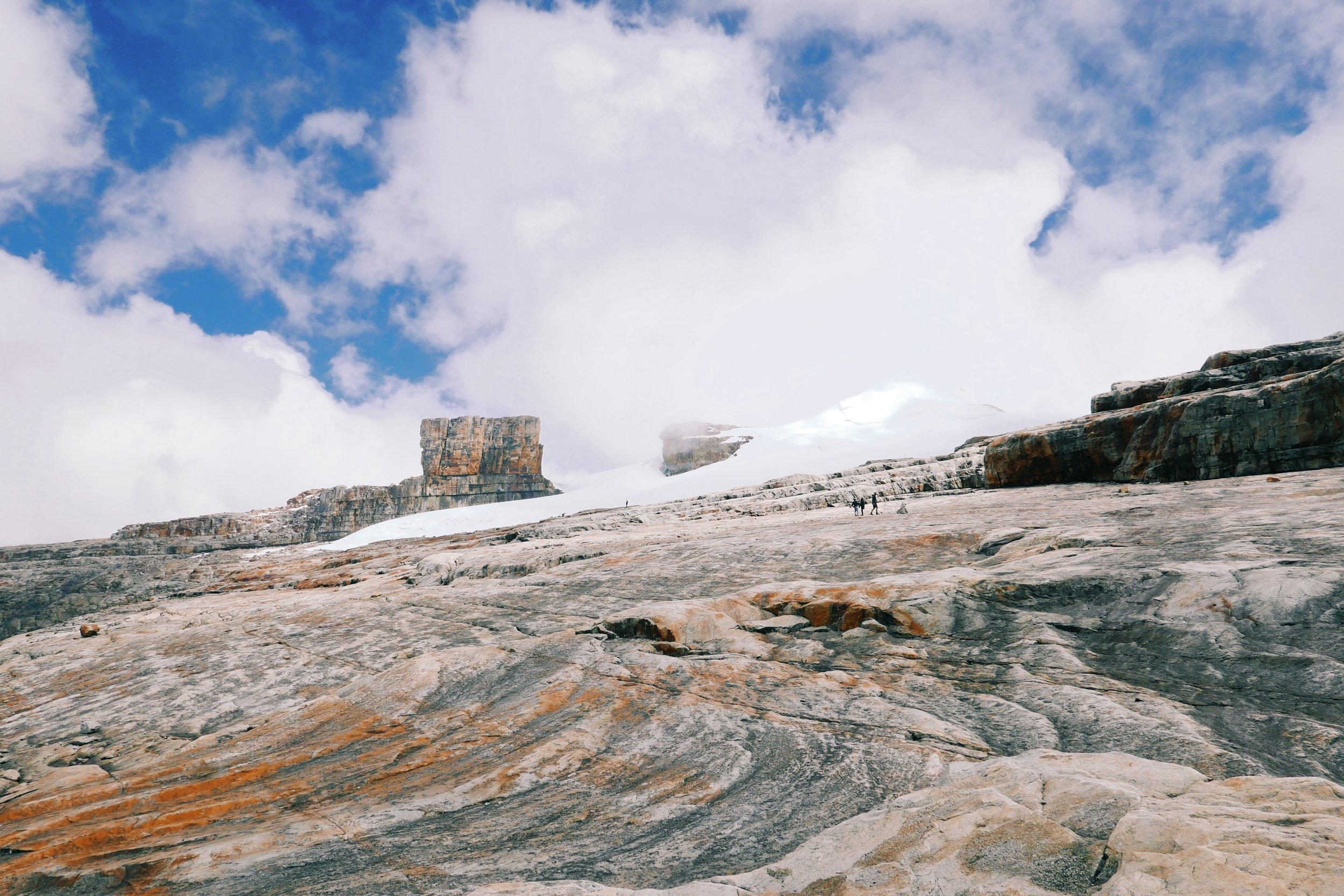
The first part of the trail is downhill & then relatively flat, taking you through a wide valley to the edge of a glacial lake. The minerals, paramos & uninhibited light transform the water into a rainbow of colours; from ice blues & deep greens, to reds & golds at the edge. From here it is a steady climb to the base of the moraine and then… it gets a little more tricky. An intensely steep climb with the use of hands & feet, scrambling over enormous boulders. A gently rising plain of ice-stripped rock then stretches out to the edge of the glacier, marking the last 20 minutes - a relief of sorts, but balanced by a bitter wind & sharp drop in temperature.
And there, drifting in and out of clouds and bracketed by ancient ice, stands El Pulpito. It’s hard, square lines looking alien in an already bizarre landscape.
Laguna Grande de la Sierra
Total Length: A little debated as it depends where you stop, but approx 22km total if you get to the edge of the glacier before turning back.
Average Time: 8-9 hours to complete.
Altitude: It starts at 3600m and finishes at the Cancavo Glacier at 4,700m.
Trail Carrying Capacity: 175 people per day
This hike starts in the fields of the sheep ranch La Esperanza. Winding along a path running parallel to the valley’s fast flowing river, the trail rewards hikers with views of waterfalls almost immediately, running like sheets across smooth, near vertical faces of rock.
As the mist rose out of the valley we were both strongly reminded of the Scottish Highlands: Rust coloured shrub & grassland, frothy white watershed & the dark green of the montane forest.
All thoughts of Scotland rapidly disappeared as we entered the Valley of the Faillejones. These plants are found in very few places throughout the world & are wonderfully weird looking. Like a cactus got cold feet & turned into a palm tree instead. Interestingly they’re actually part of the sunflower family (Steph’s favourite).
Frailljones
Frailljones only live at high altitudes & within páramo environments. Thick, stubby, almost hairy leaves cover it’s trunk helping to absorb vast amounts of water vapour from passing clouds. This water is then released through it’s roots - like any other plant in reverse. They contribute to high altitude subterranean water storage - champions of water sustainability.
After a steady ascent up the valley, the hike then steepens in gradient considerably. There is little respite until the ridge before the lakes, at which point it’s a further 20 minutes to reach Laguna Grande across loose moraine.
After hours of up-hill hiking we were so desperate to reach it we were almost prepared to believe the first minor-lagoons we came across, grey & bleak, were the main event (Steph was not impressed). A little further & we finally made it - the vast expanse of blue spread out below us, the Cancavo glacier perfectly reflected. We watched eddies of wind chase each other across the surface, before the clock struck 1 and we headed for home.
Just checking that the feet are still there…
The Ritacuba
Total Length: 13.6km (the shortest!)
Average time: 6 - 7 hours
Altitude: 3,950m rising to 4,861m (the highest!) - meaning the air gets mighty thin
Trail carrying capacity: 49 people per day
This may be the shortest hike, but it is also the steepest. Starting in a similar vain to the Laguna Grande hike, there is a short warm-up through fields of grazing sheep, before the landscape turns more rugged. Slopes filled with Frailljones give way to rocks which resemble ripples, carved by the receding Ritacuba glacier.
This hike offers unparalleled views of the Ritacuba Blanco peak, tired feet & legs rewarded with views of the most intense scale.
Do you need a guide?
In short, yes.
Due to the controls in place following the parks closure, it is no longer permitted to hike without a guide. All tourists must be accompanied if they wish to enter the park boundary, no doubt to ensure people are sticking to the trails & not attempting to camp overnight.
Whilst some may find this frustrating, we tend to find guides for high altitude & lengthy hikes very helpful. Their knowledge of the terrain, the distances & the time required to cover them helps set expectations, often making them more mentally manageable. Their commentary on local flora & fauna as well as the concentration we still require to speak & understand Spanish also make for good distractions from aching legs & tired feet.
There are two different ways you can engage a guide for El Cocuy:
End-end organisation & trail guide (this is what we did)
Trail guide only
End-end organisation & trail guide with Pablo:
We managed to find someone who would help organise our park registration, transport between hikes, accommodation & guide for a full 3 day hiking extravaganza.
Pablo offers a number of different itineraries led by several local guides, mainly a combination of the different hikes above, but also opportunities to explore the local area. He sent us a full list of all the packages he offers (sadly all in Spanish!) which can be found here. The prices were valid January 2019 - but expect these to vary.
In order to book, he asked us to provide the following:
To pay half the total cost by way of a deposit via bank transfer (easily done in any bank in-branch). Whilst this made us a touch nervous, it was all above board.
Send copies of our passports so paperwork could be pre-completed to speed up registration
We contacted, confirmed & booked all this over WhatsApp directly with Pablo before meeting our guide at our hotel in El Cocuy.
His phone number: +57 320 410 8377
His facebook page: https://www.facebook.com/profile.php?id=1167266427
Trail Guide Only:
An alternative is to find a local guide once in El Cocuy, or reach out directly ahead of time.
This is a more common route where the service you get is solely a guide for each trail. Typically guides will meet you at the start of each trail-head, and leave you after returning. This means you have to ensure you have your own transport to and from the starts of each trail as well as accommodation booked between hikes. We’ve provided a bit of guidance on this below.
In regards to finding a guide once in El Cocuy (or beforehand) you can find a list of registered guides & their contact details here & a list of interpreters here.
In addition, the owner of the local Hotel/hostel El Caminante (which we recommend, not least because of the excellent breakfast) is also a highly related & experienced guide who’s family have been guiding in the region for many years. Her name is Martha and she can be contacted here.
How fit do you need to be?
We’ve always found that with high-altitude hiking, it’s more about how persistent you are than how fit. By that we basically mean, how stubborn can you be in order to summit - so long as you have no symptoms of altitude sickness!
If you take it slowly, with plenty of breaks, both the Ritacuba & Laguna Grande hikes will be manageable for someone of average fitness. The terrain is challenging in places but by no means impossible. El Pulpito involves some clambering over tricky boulders and necessitates some very large steps up, so requires some reasonable strength.
Altitude sickness can render some of the fittest people nauseous & dizzy, and if ignored can be incredibly dangerous. DO NOT be stubborn if you experience the following, & let your guide know immediately:
Abnormally swollen fingers (beyond just ‘hiking hand’)
Headaches
Dizziness / feeling feint / blurred vision
Nausea
Do you need to register?
Yes.
If you have booked a guide who is helping you with all of your logistics, they should collect you from you hotel/hostel in El Cocuy town & take you to the registration office.
In El Cocuy this is a multi step process.
First you must provide your passport details & register in a small office. It is here that you (or your guide if arranged) will pay your entrance fee to the park. Approx $61,000 COP.
You must then head to the Park Tourism Office (literally around the corner - our guide drove us and It was a little ridiculous). Here you will show your tickets/wristbands & pay for your rescue insurance. Approx: $7,000 COP.
You will then be shown a short introductory video to the park, which helpfully provides some additional detail & information about the eco-region, geography & climate (mercifully with English subtitles).
Keep all documentation/tickets/wristbands or passes on you at all times. You will not be granted entry to the park if these are requested and you do not have them available.
If you are organising a DIY trip, the registration office addresses for the nearest municipalities are as follows:
El Cocuy: Calle 5 # 4-22. Monday – Sunday, 7am – 11:45am and 1pm – 4:45pm. Tel: (57 8) 789 0359
Guican: Transversal 4a # 6-60. Monday – Sunday, 7am – 11:45am and 1pm – 4:45pm. Tel: (57 8) 789 7280
Bogotá: User Services at Parques Nacionales Naturales. Calle 74 # 11-81. Monday – Friday, 8:30am – 5:30pm. Tel: (57 1) 353 2400, Ext. 3011, 3012
Registration cannot be done at the trail heads of Ritacuba, Laguna Grande or El Pulpito. If you reach the start of the hikes without having registered, you will be asked to return to the Park offices.
How do you get to the Trail Heads?
If you’ve opted for an end-end organisation option, all your transport to and from the park and between trails each day should be included.
If you have opted for a trail-guide only it is likely that your guide will ask to meet you at the start of the trail, as opposed to accompanying you from your accommodation in town, or on the edges of the park.
Getting to the trail heads from El Cocuy town
Unless you organise private transportation, there is only one way to get into the park, which is via la lachero (milk-truck). These milk-collection trucks leave from the main square any time between 5.30am & 7.00am (usually towards the earlier end), and are principally transporting supplies, farm workers… and, unsurprisingly, milk. A one-way ride will cost around 10,000 pesos per person.
Once you have completed your hike, you must have private transportation booked to take you to your next accommodation, or back to town. We strongly recommend this is booked & organised in advance & can be done via your hostel or cabana (just ask). Whilst there are control stations at each of the trail-heads they wont thank you if they have to organise your transport, and you’ll face a lengthy wait after an even lengthier hike.
Where can you Stay between Hikes?
Staying within the National Park is no longer permitted, though you will come across the abandoned infrastructure from when it was. A few empty cabanas, half built refuges & designated camp grounds are scattered along the lower parts of the trail, particularly on the El Pulpito hike. Don’t be fooled, you must leave the park before 6pm.
Despite this, there is no need to return to the town of El Cocuy each night if you choose to hike more than one route. Several cabanas & ranches located just outside of the park perimeter are conveniently close to starts of all hikes and are oases of rustic charm (estate agent language right there - in reality a little more draughty, often cold, a little battered, but without fail the friendliest places you’ll ever stay).
Our guide had organised our accommodation for us in advance, and we spent two nights at La Esperanza, a working sheep ranch around a 20minute walk from the Laguna Grande trail head. For both returning from the end of El Pulpito & arriving at the start of Ritacuba, we had pre-arranged transport to shuttle us. We strongly recommend you sort this transport in advance; there is nothing worse than finishing a long hike only to be faced with a longer wait for a ride.
Whilst we only stayed in one cabana, other options are available & slightly closer to the other two hikes. You can either work with your guide to help organise this, or contact the cabanas directly to book, provided you have a means of transport between them.
Accommodation near Pulpito de Diablo
If you’re doing the Pulpito hike, the best place to stay is at the Cabanas Guaicany near the start of the trail. Rooms here are around 30,000 pesos per person & 30,000 extra if you want dinner the evening before & breakfast the morning of the hike.
Accommodation near Laguna Grande
We stayed both nights a Hacienda La Esperanza, a working sheep ranch around 20 minutes walk from the start of the Laguna Grande hike. Where we had a guide who had sorted our accommodation for us we didn’t book directly, however were told that beds at the cabin cost around 30,000 Colombian pesos per person ($10 USD). You can have dinner the night before & breakfast the morning of the hike for an additional 30,000 Colombian pesos.
Clean beds, piles of blankets, full of interesting ranch equipment, photos & history. Some rooms have private bathrooms, most are shared. It get’s unfathomably cold when the weather is poor, so bring plenty of warm clothes to sleep in. The food is hearty & home made (including hot potato soup for breakfast!), you may even get the opportunity to try a desert made from their own sheep cheese & honey
If you are choosing to DIY your trip, you will need to contact the owner directly. He’s called Sergio & is a truly great character - you can get hold of him via their facebook page here: La Esperanza Facebook page here.
Do not expect to turn up at the end of a hike & get a bed without booking. A beer or a hot Agua Panella perhaps, but you will be turned away if you’re seeking a somewhere to stay & have not cleared it with Sergio.
Your guide should meet you at La Esperanza before you start your hike & you will then walk together to the trail head.
Accommodation near Ritcauba
Whilst we didn’t stay here, we kind of wish we had. Cabañas Kanwara is located nearest the Ritacuba hike. Rooms are a little more expensive at 45.000 COP per person and breakfast, lunch and dinner are available. There is a small restaurant on site. Kanwara is a great option for a touch of acclimatisation prior to hikes as well, sitting at 3,900m above sea level (12,800 feet).
For all of these options, if you’re planning to trek El Cocuy during the high (and driest) season (December - January), then we would suggest you to book well in advance (especially if you want to stay at cabanas Kanwara) - they can fill up quickly due to the limited options available.
What to Pack?
Conditions are best in El Cocuy between December & February, but we still had our fair share of showers, as well as burnt noses! As with any high-altitude hiking the weather can change rapidly & dramatically, so it is best to pack for all eventualities:
For the start of the hike we wore the following (adhering to a ‘be bold, start cold’ philosophy):
Hiking shorts / leggings
Synthetic top (or anything but cotton - natural fibres retain sweat/water & will make you cold)
Thick hiking socks (Bridgedale - always)
Comfortable, well-worn hiking boots (Scarpa crampon-compatible mountain boots for Steph, Solomon Gore-Tex hiking boots for Nick)
Hat & sunglasses
High factor suncream
In our day bags we also carried:
Thermal mid-layer (Steph will always bring her RAB tech-top for hiking- it has thumb-holes!)
Warm coat or insulation layer
Waterproof wind-breaker (our guide opted for a plastic poncho - it seemed to do the trick!)
Waterproof over-trousers (or in Nick’s case the bits he zips on to his shorts to turn them into trousers - nifty - A little nerdy, but a lot useful. Found in Decathlon, of course)
Waterproof bag cover
Buff or Snood (We both wear a Buff Original around our head & ears & Steph wears a Buff Polar / a fleecey one as a scarf)
Gloves
Refillable water bottle (800ml Klean Kanteen for Steph [opt for the sports-cap], CamelBak Chute for Nick)
Lunch & snacks
Extra suncream
Hand sanitiser & tissues
What facilities are there on the trails?
While we would have loved a warm cafe selling chocolate caliente at the end of the trail - alas... Facilities are at the very basic level. At each of the trail heads there is the following:
Control Station
Red Cross (up to 3) - they should give you a quick briefing about altitude sickness before you set off
Compost toilets (bring your own loo-roll & anti-bac hand gel)
Once you are above of the farm-land, it is possible to drink directly from the streams that come from the glacier. Cold & fresh.
How much does it cost?
Where there are relatively limited accommodation & dining options in El Cocuy & between the hikes, there is little variation in the cost of a trip.
Return bus journey from Bogota to El Cocuy Town: $65,000 COP (£16)
Accommodation in town (for the first & final night): Approx $80,000 COP pp per night (£19)
Park Entrance Fee: $61,000COP/person (£15)
Insurance: $7,000COP/person (£2)
Trail guide only: $120,000COP (spanish-speaking) for up to 6 people per day (£30)
The price for an end-end guide, accommodation, all food & transport for all 3 hikes, will vary depending on how many people you are with. At the time of writing, the prices we were quoted were as follows:
For one person: $985,000 COP/person (£245)
For two: 611,000 COP/per person (£152)
For three: 486,000 COP/per person (£121)
Pablo’s full PDF document & price list can be found here (in Spanish!). Prices were current as of January 2019.
Hiking in El Cocuy was one of the more intrepid excursions we did in Colombia, and we loved the feeling of being away from the crowds & discovering somewhere new. We hope we managed to clear up any questions you might have if you’re planning your own adventure and, as always, if you you want to know more, or somethings is not clear - just drop us a note below.
If you venture into the mountains, we’d love to hear about it! Leave a comment below
MORE ON Colombia FROM THE CURIOUS TRAVEL
Up for more adventures in Colombia? We’re forever writing more about our travels - Have a little look below for more inspiration
